Note: The Maryland Native Plant Society is a partner of our society and offers many field trips and other events throughout the year. Registration is often required so if you want to go on a trip, make sure to sign up early. 2026 Field Trips
- Friday, May 8 NMNH's Department of Botany Research Greenhouse Facility
On May 8th at 1 pm we will be visiting NMNH's Department of Botany Research Greenhouse Facility. This is a rare opportunity to see an even rarer collection of living plant specimens collected by the Department of Botany's research curators. Botanical Society of Washington Vice President Carl Johnson will be leading the tour. Please RSVP (JohnsonCA2@si.edu) by May 5th as capacity is limited and names will need to be given in advance for entry. More info on the Research Greenhouse can be found in the latest issue of The Plant Press.
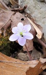
- Sunday, March 29 and Saturday, April 11 - Bear Island - C and O Canal - Mile 12.6 (Maryland) - Meet at 8:00 a.m. at the parking area across from Old Angler's Inn. The plan is for these trips to be led by the group members themselves, many of whom have been to this site a multitude of times over the past years.
The 8am start time is earlier than in the past because of the parking situation. Some parking areas which were available in the past are no longer available.
People can contact Rob Soreng via info provided here if they are running late or need reassurance. We go for a hike even if raining!
Here is a list of spring-blooming species for the area of the park we will be visiting:
It's based on Dan Nicolson's list, with some additions by Alan Whittemore.
And here is a key to the species. Alan has been updating these files for the last few years.Things to bring: lunch, water, sunscreen, hat, hand lens, binoculars, field guides, hand sanitizer, etc.
NOTE: Sorry, but dogs are not allowed on this trip.
- Great Falls area trail map
- Nature Conservancy page about the Potomac Gorge and Bear Island
- Maryland DNR brochure about the Potomac Gorge
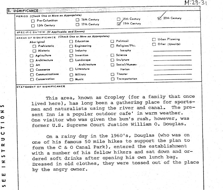
- From a 1975 document about Old Angler's Inn: item about Justice Douglas
- Full 1975 document can be found here.
- Saturday, April 4
Time: 9 a.m
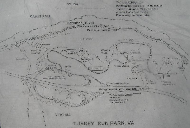
Where: Turkey Run Park, part of the national park, The George Washington Memorial Parkway
Map of Turkey Run - showing meeting spot near Park Police Headquarters.Coming from Maryland, you can go the long way via the Turkey run loop Road, or get in the left lane and turn left at the unmarked entrance to the HQ and park police station. There is a left turn lane on the Parkway at this point. This is hard to spot on Google maps but can be seen if one looks at the satellite version of the map.
People can contact Rob Soreng via info provided here if they are running late or have other questions.
- Edd has updated his Biodiversity of the Potomac River Valley Workbook and has made it available in two font sizes.
Biodiversity of the Potomac River Valley - Smaller Font 33 pages
Biodiversity of the Potomac River Valley - Larger Font - 63 pages
Turkey Run Vegetation Map
2025 Field Trips
- Saturdays, March 29 and April 12 - Bear Island - C and O Canal - Mile 12.6 (Maryland) - Meet at 8:00 a.m. at the parking area across from Old Angler's Inn. The plan is for these trips to be led by the group members themselves, many of whom have been to this site a multitude of times over the past years.
The 8am start time is earlier than in the past because of the parking situation. Some parking areas which were available in the past are no longer available.
People can contact Paul Peterson at 301-412-4212 if they are running late or need reassurance. We go for a hike even if raining!
Here is a list of spring-blooming species for the area of the park we will be visiting:
It's based on Dan Nicolson's list, with some additions by Alan Whittemore.
And here is a key to the species. Alan has been updating these files for the last few years.Things to bring: lunch, water, sunscreen, hat, hand lens, binoculars, field guides, hand sanitizer, etc.
NOTE: Sorry, but dogs are not allowed on this trip.
- Great Falls area trail map
- Nature Conservancy page about the Potomac Gorge and Bear Island
- Maryland DNR brochure about the Potomac Gorge
- From a 1975 document about Old Angler's Inn: item about Justice Douglas
- Full 1975 document can be found here.
- Saturday, April 5
Time: 9 a.m
Where: Turkey Run Park, part of the national park, The George Washington Memorial Parkway
Map of Turkey Run - showing meeting spot near Park Police Headquarters.Coming from Maryland, you can go the long way via the Turkey run loop Road, or get in the left lane and turn left at the unmarked entrance to the HQ and park police station. There is a left turn lane on the Parkway at this point. This is hard to spot on Google maps but can be seen if one looks at the satellite version of the map.
People can contact Paul Peterson at 301-412-4212 if they are running late.
- Edd has updated his Biodiversity of the Potomac River Valley Workbook and has made it available in two font sizes.
Biodiversity of the Potomac River Valley - Smaller Font 33 pages
Biodiversity of the Potomac River Valley - Larger Font - 63 pages
Turkey Run Vegetation Map
2024 Field Trips
- Saturdays, March 30 and April 13 - Bear Island - C and O Canal - Mile 12.6 (Maryland) - Meet at 8:00 a.m. at the parking area across from Old Angler's Inn. The plan is for these trips to be led by the group members themselves, many of whom have been to this site a multitude of times over the past years.
The 8am start time is earlier than in the past because of the parking situation. Some parking areas which were available in the past are no longer available.
People can contact Paul Peterson at 301-412-4212 if they are running late or need reassurance. We go for a hike even if raining!
Here is a list of spring-blooming species for the area of the park we will be visiting:
It's based on Dan Nicolson's list, with some additions by Alan Whittemore.
And here is a key to the species. Alan has been updating these files for the last few years.Things to bring: lunch, water, sunscreen, hat, hand lens, binoculars, field guides, hand sanitizer, etc.
NOTE: Sorry, but dogs are not allowed on this trip.
- Great Falls area trail map
- Nature Conservancy page about the Potomac Gorge and Bear Island
- Maryland DNR brochure about the Potomac Gorge
- From a 1975 document about Old Angler's Inn: item about Justice Douglas
- Full 1975 document can be found here.
- Saturday, April 6
Time: 9 a.m
Where: Turkey Run Park, part of the national park, The George Washington Memorial Parkway
Map of Turkey Run - showing meeting spot near Park Police Headquarters.Coming from Maryland, you can go the long way via the Turkey run loop Road, or get in the left lane and turn left at the unmarked entrance to the HQ and park police station. There is a left turn lane on the Parkway at this point. This is hard to spot on Google maps but can be seen if one looks at the satellite version of the map.
People can contact Paul Peterson at 301-412-4212 if they are running late.
- Edd has updated his Biodiversity of the Potomac River Valley Workbook and has made it available in two font sizes.
Biodiversity of the Potomac River Valley - Smaller Font 33 pages
Biodiversity of the Potomac River Valley - Larger Font - 63 pages
Turkey Run Vegetation Map
- Saturday, April 20
Time: 10 a.m.
Where: Parking area to the right of the Ferry Hill mansion. The driveway into the mansion is just across from Canal Road.
Things to bring: lunch, water, sunscreen, hat, walking stick, hand lens, binoculars, field guides, hand sanitizer, etc.
The address of the mansion 16500 Shepherdstown Pike, Sharpsburg, MD 21782.
Further info about Ferry Hill mansion, plants, etc.: http://www.botsoc.org/ferryhill.html
If you have a question, write to Kathy at kathy at-the-domain fred.net.
NOTE: There is a little coffee and sweet shop quite close to the entrance to the mansion, about 1000 feet east towards Sharpsburg. There is also a brewery (several years in the making) at the same location.
At 3pm across the river in Shepherdstown - Beatlemania! - A pop-up film series 4/20 & 4/28
...
...
...
...
.
2023 Field Trips
- Saturdays, March 25 and April 8 - Bear Island - C and O Canal - Mile 12.6 (Maryland) - Meet at 8:00 a.m. at the parking area across from Old Angler's Inn. The plan is for these trips to be led by the group members themselves, many of whom have been to this site a multitude of times over the past years.
The 8am start time is earlier than in the past because of the parking situation. Some parking areas which were available in the past are no longer available.
People can contact Paul Peterson at 301-412-4212 if they are running late or need reassurance. We go for a hike even if raining!
And please remember to keep your distance!
Here is a list of spring-blooming species for the area of the park we will be visiting:
It's based on Dan Nicolson's list, with some additions by Alan Whittemore.
And here is a key to the species. Alan has been updating these files for the last few years.Things to bring: lunch, water, sunscreen, hat, hand lens, binoculars, field guides, hand sanitizer, etc.
NOTE: Sorry, but dogs are not allowed on this trip.
- Great Falls area trail map
- Nature Conservancy page about the Potomac Gorge and Bear Island
- Maryland DNR brochure about the Potomac Gorge
- From a 1975 document about Old Angler's Inn: item about Justice Douglas
- Full 1975 document can be found here.
- Saturday, April 1
Time: 9 a.m
Where: Turkey Run Park, part of the national park, The George Washington Memorial Parkway
Map of Turkey Run - showing meeting spot near Park Police Headquarters.Coming from Maryland, you can go the long way via the Turkey run loop Road, or get in the left lane and turn left at the unmarked entrance to the HQ and park police station. There is a left turn lane on the Parkway at this point. This is hard to spot on Google maps but can be seen if one looks at the satellite version of the map.
- Edd has updated his Biodiversity of the Potomac River Valley Workbook and has made it available in two font sizes.
Biodiversity of the Potomac River Valley - Smaller Font 33 pages
Biodiversity of the Potomac River Valley - Larger Font - 63 pages
Turkey Run Vegetation Map
- Saturday, April 22
Time: 10 a.m.
Where: Parking area to the right of the Ferry Hill mansion. The driveway into the mansion is just across from Canal Road.
Things to bring: lunch, water, sunscreen, hat, hand lens, binoculars, field guides, hand sanitizer, etc.
The address of the mansion 16500 Shepherdstown Pike, Sharpsburg, MD 21782.
If you have a question, write to Kathy at kathy at-the-domain fred.net.
NOTE: There is a new little coffee and sweet shop quite close to the entrance to the mansion, about 1000 feet east towards Sharpsburg.
.
2022 Field Trips
- Saturdays, March 26 and April 9 - Bear Island - C and O Canal - Mile 12.6 (Maryland) - Meet at 8:00 a.m. at the parking area across from Old Angler's Inn. The plan is for these trips to be led by the group members themselves, many of whom have been to this site a multitude of times over the past years.
The 8am start time is earlier than in the past because of the parking situation. Some parking areas which were available in the past are no longer available.
People can contact Paul Peterson at 301-412-4212 if they are running late or need reassurance. We go for a hike even if raining!
And please remember to keep your distance!
Here is a list of spring-blooming species for the area of the park we will be visiting:
It's based on Dan Nicolson's list, with some additions by Alan Whittemore.
And here is a key to the species. Alan has been updating these files for the last few years.Things to bring: lunch, water, sunscreen, hat, hand lens, binoculars, field guides, hand sanitizer, etc.
- Great Falls area trail map
- Nature Conservancy page about the Potomac Gorge and Bear Island
- Maryland DNR brochure about the Potomac Gorge
- From a 1975 document about Old Angler's Inn: item about Justice Douglas
- Full 1975 document can be found here.
- Saturday, April 2
Time: 9 a.m
Where: Turkey Run Park, part of the national park The George Washington Memorial Parkway
Map of Turkey Run - showing meeting spot near Park Police Headquarters.Coming from Maryland, you can go the long way via the Turkey run loop Road, or get in the left lane and turn left at the unmarked entrance to the HQ and park police station. There is a left turn lane on the Parkway at this point. This is hard to spot on Google maps but can be seen if one looks at the satellite version of the map.
- Edd has updated his Biodiversity of the Potomac River Valley Workbook and has made it available in two font sizes.
Biodiversity of the Potomac River Valley - Smaller Font 33 pages
Biodiversity of the Potomac River Valley - Larger Font - 63 pages
- Turkey Run Vegetation Map
2021 Field Trips
- Saturdays, March 27 and April 10 - Bear Island - C and O Canal - Mile 12.6 (Maryland) - Meet at 8:00 a.m. at the parking area across from Old Angler's Inn. The plan is for these trips to be led by the group members themselves, many of whom have been to this site a multitude of times over the past years.
The 8am start time is earlier than in the past because of the parking situation. Some parking areas which were available in the past are no longer available.
People can contact Paul Peterson at 301-412-4212 if they are running late or need reassurance. We go for a hike even if raining!
And please remember to keep your distance!
Here is a list of spring-blooming species for the area of the park we will be visiting:
It's based on Dan Nicolson's list, with some additions by Alan Whittemore.
And here is a key to the species. Alan has been updating these files for the last few years.Things to bring: lunch, water, sunscreen, hat, hand lens, binoculars, field guides, hand sanitizer, etc.
- Great Falls area trail map
- Nature Conservancy page about the Potomac Gorge and Bear Island
- Maryland DNR brochure about the Potomac Gorge
- From a 1975 document about Old Angler's Inn: item about Justice Douglas
- Full 1975 document can be found here.
- Saturday, April 3
Time: 9 a.m
Where: Turkey Run Park, part of the national park The George Washington Memorial Parkway
Map of Turkey Run - showing meeting spot near Park Police Headquarters.Coming from Maryland, you can go the long way via the Turkey run loop Road, or get in the left lane and turn left at the unmarked entrance to the HQ and park police station. There is a left turn lane on the Parkway at this point. This is hard to spot on Google maps but can be seen if one looks at the satellite version of the map.
- Edd has updated his Biodiversity of the Potomac River Valley Workbook and has made it available in two font sizes.
Biodiversity of the Potomac River Valley - Smaller Font 33 pages
Biodiversity of the Potomac River Valley - Larger Font - 63 pages
- Turkey Run Vegetation Map
2020 Field Trips
- Saturdays, March 28 and April 11 - Bear Island - C and O Canal - Mile 12.6 (Maryland) - Meet at 9:00 a.m. at the parking area across from Old Angler's Inn. The plan is for these trips to be led by the group members themselves, many of whom have been to this site a multitude of times over the past years.
People can contact Paul Peterson at 301-412-4212 if they are running late or need reassurance. We go for a hike even if raining!
And please remember to keep your distance!
Here is a list of spring-blooming species for the area of the park we will be visiting:
It's based on Dan Nicolson's list, with some additions by Alan Whittemore.
And here is a key to the species. Alan has been updating these files for the last few years.Things to bring: lunch, water, sunscreen, hat, hand lens, binoculars, field guides, hand sanitizer, etc.
- Great Falls area trail map
- Nature Conservancy brochure about Bear Island
- Maryland DNR brochure about the Potomac Gorge
- From a 1975 document about Old Angler's Inn: item about Justice Douglas
- Full 1975 document can be found here.
- Saturday, April 4
Time: 9 a.m
Where: Turkey Run Park, part of the national park The George Washington Memorial Parkway
Map of Turkey Run - showing meeting spotComing from Maryland, you can go the long way via the Turkey run loop Road, or get in the left lane and turn left at the unmarked entrance to the HQ and park police station. There is a left turn lane on the Parkway at this point. This is hard to spot on Google maps but can be seen if one looks at the satellite version of the map.
- Edd has updated his Biodiversity of the Potomac River Valley Workbook and has made it available in two font sizes.
Biodiversity of the Potomac River Valley - Smaller Font 33 pages
Biodiversity of the Potomac River Valley - Larger Font - 63 pages
- Turkey Run Vegetation Map
2019 Field Trips
- Saturdays, April 6 and April 20 - Bear Island - C and O Canal - Mile 12.6 (Maryland), meet at 9:00 a.m. at the parking area across from Old Angler's Inn. The plan is for these trips to be led by the group members themselves, many of whom have been to this site a multitude of times over the past years.
Here is a list of spring-blooming species for the area of the park we will be visiting:
It's based on Dan Nicolson's list, with some additions by Alan Whittemore.
And here is a key to the species. Alan has been updating these files for the last few years.Things to bring: lunch, water, sunscreen, hat, hand lens, binoculars, field guides, etc.
- Great Falls area trail map
- Nature Conservancy brochure about Bear Island
- Maryland DNR brochure about the Potomac Gorge
- From a 1975 document about Old Angler's Inn: item about Justice Douglas
- Full 1975 document can be found here.
- Saturday, April 13
Time: 9 a.m
Where: Turkey Run Park, part of the national park The George Washington Memorial Parkway
Map of Turkey Run - showing meeting spotComing from Maryland, you can go the long way via the Turkey run loop Road, or get in the left lane and turn left at the unmarked entrance to the HQ and park police station. There is a left turn lane on the Parkway at this point. This is hard to spot on Google maps but can be seen if one looks at the satellite version of the map.
- Edd has updated his Biodiversity of the Potomac River Valley Workbook and has made it available in two font sizes.
Biodiversity of the Potomac River Valley - Smaller Font 33 pages
Biodiversity of the Potomac River Valley - Larger Font - 63 pages
- Turkey Run Vegetation Map
2018 Field Trips
- Saturdays, March 31 and April 14 - Bear Island - C and O Canal - Mile 12.6 (Maryland), meet at 9:00 a.m. at the parking area across from Old Angler's Inn. The plan is for these trips to be led by the group members themselves, many of whom have been to this site a multitude of times over the past years.
Here is a list of spring-blooming species for the area of the park we will be visiting:
It's based on Dan Nicolson's list, with some additions by Alan Whittemore.
And here is a key to the species. Alan has been updating these files for the last few years.Things to bring: lunch, water, sunscreen, hat, hand lens, binoculars, field guides, etc.
- Great Falls area trail map
- Nature Conservancy brochure about Bear Island
- Maryland DNR brochure about the Potomac Gorge
- From a 1975 document about Old Angler's Inn: item about Justice Douglas
- Full 1975 document can be found here.
- Saturday, April 7
Time: 9 a.m
Where: Turkey Run Park, part of the national park The George Washington Memorial Parkway
Map of Turkey Run - showing meeting spotComing from Maryland, you can go the long way via the Turkey run loop Road, or get in the left lane and turn left at the unmarked entrance to the HQ and park police station. There is a left turn lane on the Parkway at this point. This is hard to spot on Google maps but can be seen if one looks at the satellite version of the map.
- Edd has updated his Biodiversity of the Potomac River Valley Workbook and has made it available in two font sizes.
Biodiversity of the Potomac River Valley - Smaller Font 33 pages
Biodiversity of the Potomac River Valley - Larger Font - 63 pages
- Turkey Run Vegetation Map
2017 Field Trips
- Sunday, December 17 10am - 4pm
Celebrate the beginning of the winter season at Mattawoman Wildlands at Chapman Forest (the vast section of Chapman Forest South abutting Mattawoman Wildlands) with its spectacular scenery and remarkable diversity of native plants, wildlife, and natural communities! It has been 8 ½ years since we last visited this forest, for a jointly sponsored Summer Solstice Field Trip.
See details here.
- Sunday, July 9 - Bear Island - C and O Canal - Mile 12.6 (Maryland), meet at TBD at the parking area across from Old Angler's Inn. The plan is for these trips to be led by the group members themselves, many of whom have been to this site a multitude of times over the past years. This is the first summer trip to this location in a number of years.
Here is a list for Plummers Island: Plummer_Island_plant_list_2_2017.pdf
- Saturdays, March 25 and April 15 - Bear Island - C and O Canal - Mile 12.6 (Maryland), meet at 9:00 a.m. at the parking area across from Old Angler's Inn. The plan is for these trips to be led by the group members themselves, many of whom have been to this site a multitude of times over the past years.
Here is a list of spring-blooming species for the area of the park we will be visiting:
It's based on Dan Nicolson's list, with some additions by Alan Whittemore.
And here is a key to the species. Alan has been updating these files for the last few years.Things to bring: lunch, water, sunscreen, hat, hand lens, binoculars, field guides, etc.
- Great Falls area trail map
- Nature Conservancy brochure about Bear Island
- Maryland DNR brochure about the Potomac Gorge
- From a 1975 document about Old Angler's Inn: item about Justice Douglas
- Full 1975 document can be found here.
- Saturday, April 1
Time: 10 a.m
Where: Turkey Run Park, part of the national park The George Washington Memorial Parkway
Map of Turkey Run - showing meeting spot
- Edd has updated his Biodiversity of the Potomac River Valley Workbook and has made it available in two font sizes.
Biodiversity of the Potomac River Valley - Smaller Font 33 pages
Biodiversity of the Potomac River Valley - Larger Font - 63 pages
- Turkey Run Vegetation Map
2016 Field Trips
- Sunday, December 18 - Chapman Forest in Charles County, Maryland (Chapman State Park) - Pictures from trip
- Saturday, August 6 MANUMUSKIN RIVER WATERSHED, CUMBERLAND COUNTY, NJ
Joint trip with Philadelphia Botanical Club and Torrey Botanical Society. This trip will explore the various environments of the Manumuskin River watershed. This area is one of the few places in Cumberland Co. to see typical Pine Barrens vegetation, including Pyxidanthera barbulata and Xerophyllum asphodeloides. Rare species we will be looking for include: Amianthium muscitoxicum, Andropogon gyrans, Calamovilfa brevipilis, Chionanthus virginicus, Croton wildenowii, Desmodium laevigatum, Desmodium strictum, Gymnopogon ambiguus, Lespedeza stuevei, Lobelia canbyi, Panicum hemitomon, Platanthera cristata, P. ciliaris, Quercus michauxii, Schizaea pusilla, Scleria minor, Scleria pauciflora, Scleria reticularis, Toxicodendron pubescens, and Utricularia purpurea. If there is time, we will visit the tidal portion of the river to look for the federally-threatened Aeschynomene virginica. The area also has a rich history, and we will be in the vicinity of some these historical sites, including the Defiance bloomery forge (est. ca. 1785) and the Cumberland Iron Furnace (est. 1810). Directions: Contract trip leaders for meeting location and time.Trip leaders: Uli Lorimer, ulrichlorimer at bbg.org, 718-623-7200; and Gerry Moore, gerry.moore at gnb.usda.gov, 336-370-3337
URL: http://www.torreybotanical.org/field-trips/
- Saturdays, April 2 and 16 - Bear Island - C and O Canal - Mile 12.6 (Maryland), meet at 9:00 a.m. at the parking area across from Old Angler's Inn. The plan is for these trips to be led by the group members themselves, many of whom have been to this site a multitude of times over the past years.
Here is a list of spring-blooming species for the area of the park we will be visiting:
It's based on Dan Nicolson's list, with some additions by Alan Whittemore.
And here is a key to the species. Alan has been updating these files for the last few years.Things to bring: lunch, water, sunscreen, hat, hand lens, binoculars, field guides, etc.
- Great Falls area trail map
- Nature Conservancy brochure about Bear Island
- Maryland DNR brochure about the Potomac Gorge
- From a 1975 document about Old Angler's Inn: item about Justice Douglas
- Full 1975 document can be found here.
2015 Field Trips
- Saturdays, April 4 and 18 - Bear Island - C and O Canal - Mile 12.6 (Maryland), meet at 9:00 a.m. at the parking area across from Old Angler's Inn. The plan is for these trips to be led by the group members themselves, many of whom have been to this site a multitude of times over the past years.
Here is a list of spring-blooming species for the area of the park we will be visiting:
It's based on Dan Nicolson's list, with some additions by Alan Whittemore.
And here is a key to the species. Alan has been updating these files for the last few years.Things to bring: lunch, water, sunscreen, hat, hand lens, binoculars, field guides, etc.
- Great Falls area trail map
- Nature Conservancy brochure about Bear Island
- Maryland DNR brochure about the Potomac Gorge
- From a 1975 document about Old Angler's Inn: item about Justice Douglas
- Full 1975 document can be found here.
2014 Field Trips
- Saturday, April 5 and 19 - Bear Island - C and O Canal - Mile 12.6 (Maryland), meet at 9:00 a.m. at the parking area across from Old Angler's Inn. The plan is for these trips to be led by the group members themselves, most of whom have been to this site a multitude of times over the past years.
Here is a list of spring-blooming species for the area of the park we will be visiting. It's based on Dan Nicolson's list, with some additions by Alan Whittemore. Bear_Island_list_7_March_2013.pdf And here is a key to the species. Bear_Island_key_7_March_2013.pdf
Things to bring: lunch, water, sunscreen, hand lens, binoculars, field guides, etc.
From a 1975 document about Old Angler's Inn: item about Justice Douglas
Full document can be found here.
- Saturday, April 12 9:50 a.m - 1:00 p.m.
Where: Turkey Run Park, part of the national park The George Washington Memorial Parkway - Parking lot C-1. Map of Turkey Run
2013 Field Trips
- February 3 - Hemlock Overlook Regional Park
- Saturday, April 6 - Bear Island - C and O Canal - Mile 12.6 (Maryland), meet at 9:00 a.m. at the parking area across from Old Angler's Inn.
Here is a list of spring-blooming species for the area of the park we will be visiting. It's based on Dan Nicolson's list, with some additions by Alan Whittemore. Bear_Island_list_7_March_2013.pdf And here is a key to the species. Bear_Island_key_7_March_2013.pdf
- Saturday, April 13 9:50 a.m - 1:00 p.m.
Where: Turkey Run Park, part of the national park The George Washington Memorial Parkway - Parking lot C-1. Map of Turkey Run
Notes: We will be in a national park where it is illegal to disturb or collect anything. The hike is of medium rigor since we will walk down the zig-zag steps down a steep valleyside, walk up a hill, and cross 1 or 2 large rocky streams. Be prepared for different weather from light rain through a sunny day. Wear layers of clothes if needed, and bring a backpack to carry your lunch and extra clothes. We are likely to cancel our trip due to medium or heavy rain. There is a restroom in the park at the beginning and end of our walk. For forging the stream, you might find a walking stick useful. If the water is high, you need waterproof footware. BYO lunch. At about noon, we will have lunch on the shore of the Potomac River across from Plummers Island, MD.
Things to see, hear, or both, include habitats and organisms. Habitats: Boulder forest, floodplain forest, mowed parkland, oak upland forest, river, and streams. Organisms: Andrena bees, American Cancer-roots, American Robins, Asian Clams, Bladdernuts, Bloodroots, Blue Cohoshes, Boxelders, Bumble Bees, Canada Geese, Carolina Wrens, Carrionflowers, Chestnut Oaks, craneflies, Cutleaf Toothworts, Dancing Whites, Eastern Sycamores, Eastern Tiger Swallowtails, Fish Crows, fungi, invasive species, Garlic-mustards, Great Blue Herons, Green Ashes, Mallards, Nomada bees, Pawpaws, Periwinkles, Northern Red Oaks, Ostrich Ferns, River Birches, Spring Azures, sweat bees, Toad Trilliums, Tuliptrees, Twinleafs, Troutlilies, Virginia Bluebells, Western Honey Bees, and Woodland Geraniums. This trip might occur during, before, or after the height of the flowering of spring ephemerals, depending on weather. An excellent, general field guide for our hike is Alden et al. (2008), National Audubon Society, Field Guide to the Mid-Atlantic States.
Contact: barrowse@georgetown.edu, RSVP.
We plan to meet in parking lot C1 at 9:50 a.m.
Sponsors: Botanical Society of Washington; GU Center for the Environment (GUCFE); GU Department of Biology; GU; GU Science, Technology, and International Affairs (STIA)
Cost: Free, open to the public.
- Saturday, April 20 - same as for April 6.
The plan is for these trips to be led by the group members themselves, most of whom have been to this site a multitude of times over the past years.
2012 Field Trips
Notes: The walk involves level paths and paths downhill and up a low hill. We will meet in the parking lot by the Ziz-zag Stairs, walk down the Stairs, and walk on the Potomac Heritage Trail west to near the American Legion Bridge. We'll visit a riverine floodplain forest, upland forest, cliff habitat, and a sandy area. The organisms that we'll note range from archaeans and bacteria through protistans (algae) through fungi, plants, and animals. Emphasis is on plants and insects. Many of the the spring wildflowers should be at their peak during our visit. We will likely see several bird species. Edd will have a downloadable handout for the adventure.- Saturday, March 31 - Bear Island - C and O Canal - Mile 12.6 (Maryland), meet at 9:00 a.m. at the parking area across from Old Angler's Inn.
Here is a list of spring-blooming species for the area of the park we will be visiting. It's based on Dan Nicolson's list, with some additions by Alan Whittemore. Bear_Island_list_April_2011.pdf And here is a key to the species. Bear_Island_key_April_2011.pdf
- Saturday, April 7 - same as for March 31.
The plan is for these trips to be led by the group members themselves, most of whom have been to this site a multitude of times over the past years.
- Saturday, April 14
When: Saturday, 14 April 2010, 10:00 a.m - 1:00 p.m.
Where: Turkey Run Park, part of the national park The George Washington Memorial Parkway
Cost: Free, open to the public.
Species list for Turkey Run: 2000_list_Earth_All_110416_425kb.rtf
Contact: Edd Barrows, barrowse@georgetown.edu
More information: Turkey Run Park is located in McLean, Virginia, two miles south of the Capital Beltway (Interstate 495) in the national park the George Washington Memorial Parkway (GWMP). From Beltway Exit 14, follow the GWMP south 2 miles to the Turkey Run Park exit on the right. Follow signs into the Park. From Washington, D.C., and Old Town Alexandria, take the GWMP north approximately 8 miles and exit right at the Turkey Run Park sign. Make the first right turn into the Park.
Sponsor(s): Botanical Society of Washington; GU Biology Club; GU Center for the Environment (GUCFE); GU Department of Biology; GU EcoAction; GU Outdoor Education; GU Science, Technology, and International Affairs (STIA)
2011 Field Trips
2010 Field Trips
Notes: The walk involves level paths and paths downhill and up a low hill. We will meet in the parking lot by the Ziz-zag Stairs, walk down the Stairs, and walk on the Potomac Heritage Trail west to near the American Legion Bridge. We'll visit a riverine floodplain forest, upland forest, cliff habitat, and a sandy area. The organisms that we'll note range from archaeans and bacteria through protistans (algae) through fungi, plants, and animals. Emphasis is on plants and insects. Many of the the spring wildflowers should be at their peak during our visit. We will likely see several bird species. Edd will have a downloadable handout for the adventure.- Saturday, April 2 - Bear Island - C and O Canal - Mile 12.6 (Maryland), meet at 9:00 a.m. at the parking area across from Old Angler's Inn.
Here is a list of spring-blooming species for the area of the park we will be visiting. It's based on Dan Nicolson's list, with some additions by Alan Whittemore. Bear_Island_list_April_2011.pdf And here is a key to the species. Bear_Island_key_April_2011.pdf
- Saturday, April 9 - same as for April 2.
The plan is for these trips to be led by the group members themselves, most of whom have been to this site a multitude of times over the past years.
- Sunday, April 17
When: Sunday, 17 April 2010, 10:00 a.m - 1:00 p.m.
Where: Turkey Run Park, part of the national park The George Washington Memorial Parkway
Cost: Free, open to the public.
Species list for Turkey Run: 2000_list_Earth_All_110416_425 kb.rtf
Contact: Edd Barrows, barrowse@georgetown.edu
More information: Turkey Run Park is located in McLean, Virginia, two miles south of the Capital Beltway (Interstate 495) in the national park the George Washington Memorial Parkway (GWMP). From Beltway Exit 14, follow the GWMP south 2 miles to the Turkey Run Park exit on the right. Follow signs into the Park. From Washington, D.C., and Old Town Alexandria, take the GWMP north approximately 8 miles and exit right at the Turkey Run Park sign. Make the first right turn into the Park.
Sponsor(s): Botanical Society of Washington; GU Biology Club; GU Center for the Environment (GUCFE); GU Department of Biology; GU EcoAction; GU Outdoor Education; GU Science, Technology, and International Affairs (STIA)
- MAy 8, Saturday - Plummers Island
- May 28-29 - Poconos
Two upcoming fieldtrips to Pennsylvania. These are not BSW trips but all BSW members are welcome to come on the trips. Both will be led by Lou Aronica.
- Saturday, May 8 - Mothers' Day Weekend in Pennsylvania's Ridge & Valley Province
- Saturday, June 5 - Sweetbay Magnolia in Central Pennsylvania
OLD
- Saturday, April 3 - Bear Island - C and O Canal - Mile 12.6 (Maryland), meet at 9:00 a.m. at the parking area across from Old Angler's Inn.
Here is a list of spring-blooming species for the area of the park we will be visiting. It's based on Dan Nicolson's list, with some additions by Alan Whittemore. Bear_Island_list_March_2010.pdf And here is a key to the species. Bear_Island_key_March_2010.pdf
- Saturday, April 10 - same as for April 3.
The plan is for these trips to be led by the group members themselves, most of whom have been to this site a multitude of times over the past years.
- Saturday, April 17
When: Saturday, 17 April 2010, 9:30 a.m ? 12:30 p.m.
What:\A0 Biodiversity Workshop Walk at Turkey Run Park, VA
Who: Led by Edd Barrows
Where: Turkey Run Park, part of the national park The George Washington Memorial Parkway (http://www.nps.gov/archive/gwmp/vapa/turkey.htm)Cost: Free, open to the public.
Notes: The walk is limited to 25 people so everyone can hear Edd. We willbe in a national park where it is illegal to disturb or collect anything.The hike is of medium rigor since we will walk down the zig-zag steps whichare on a steep valley side, walk up a hill, and cross 1\962 large rockystreams.\A0 Be prepared for\A0 weather from light rain through a sunny day.\A0Wear layers of clothes if needed, and bring a backpack to carry your lunchand extra clothes.\A0 We are likely to cancel our trip due to medium throughheavy rain.\A0 There is a restroom in the park at the beginning and end ofour walk.\A0 For forging streams, you might find a walking stick useful.\A0 BYOlunch.\A0 At about noon, we will have lunch on the shore of the Potomac Riveracross from Plummers Island, MD.\A0 Things that we perceive, include Andrenabees, American Cancer-roots, American Robins, Bladdernuts, Blue Cohoshes,Canada Geese, Carolina Wrens, Carrionflowers, Chestnut Oaks, crane flies,Dancing Whites, Eastern Sycamores, Eastern Tiger Swallowtails, invasivespecies, Great Blue Herons, Green Ashes, Mallards, Nomada bees, Pawpaws,Northern Red Oaks, River Birches, Spring Azures, sweat bees, ToadTrilliums, Tuliptrees, Twinleafs, views of the Potomac River, Troutlilies,Virginia Bluebells, Western Honey Bees, and Woodland Geraniums.\A0 This tripwill occur at the height of the flowering of colorful spring ephemerals, ora little later, depending on weather.\A0 An excellent field guide for ourhike is Alden et al. (2007, 2008), National Audubon Society Field Guide tothe Mid-Atlantic States.
Contact: Edd Barrows, barrowse@georgetown.edu
More information: Turkey Run Park is located in McLean, Virginia, two miles south of the Capital Beltway (Interstate 495) in the national park the George Washington Memorial Parkway (GWMP). From Beltway Exit 14, follow the GWMP south 2 miles to the Turkey Run Park exit on the right. Follow signs into the Park. From Washington, D.C., and Old Town Alexandria, take the GWMP north approximately 8 miles and exit right at the Turkey Run Park sign. Make the first right turn into the Park.
2009 Field Trips
- Saturday, April 4 - Bear Island - C and O Canal - Mile 12.6 (Maryland), meet at 9:00 a.m. at the parking area across from Old Angler's Inn.
Details - Maps, plantlists, etc.A few Pictures from the trip. And some more pictures.
- Saturday, April 11 - Turkey Run Park (Virginia), meeting at parking lot C-1 at 9:30 a.m.
Each person should have a map so we can study plant communities together. People who want the long handout for the trip are certainly welcome to print it. I put a table of contents in the handout?s beginning to help people pick and choose what they might wish to print for themselves.
- The Biodiversity workbook for our Saturday biodiversity walk is at:
https://gushare.georgetown.edu/xythoswfs/webui/_xy-5698700_1-t_KnPgwL56
- Our plant communities map is at
https://gushare.georgetown.edu/xythoswfs/webui/_xy-5698701_1-t_QZ6qxgZ4The key to the map is at the end of the handout (workbook) or can be found here.
- The various stops on the trip.
- A map of parking and trails at TRP is here.
- Pictures from Turkey Run two days after the trip.
- Victoria Batista's pictures from the April 11 turkey Run trip:
- April 25-26 - St. Anthony's Wilderness, PA, - oak-heath forest in the Ridge and Valley: rare orchids; heaths; maybe get to a high-elevation black spruce peatland.
Directions: Proceed to Harrisburg, PA via I-83 (Baltimore Area) or I-270 and Route 15 (D.C. area). Take Route 22-322 about 7 miles north to the town of Dauphin ? exit into town about 1000 feet ? and gather in front of small shopping area on left.
Meeting Time: 10 a.m.
Bring: Lunch, water, and footwear for some moist but rocky terrain.
Contact: If you are late or lost, call Lou Aronica's cell phone 703-597-3711 to hook up.Rob Soreng also sent location of a campground where he and Nancy are planning to camp:
Swatara State Park
N40 32.414 W76 27.788 NE pt.
N40 29.839 W76 31.980 SE pt. on Gold Mine Run rd.
ca 23 to 28 mi ENE of Duncannon, just off and N of hwy 81This trip could be a one day or an 2-day overnight trip, depending onfolks' interest. There's a nice place to stay and eat nearby forovernighters:
Doyle Hotel in Duncannon, PA http://www.doylehotel.com (717)834-6789. The place caters especially to AT hikers and has nice rooms for $25 anight.
Someone recommended: “ The Stardust Motel on Rte 15 in Duncannon, 717-834-4433,is also a good choice. Not quite as cheap as Doyle Hotel, but very reasonableand you get your own bathroom.”
- May 9 - Join MNPS and VNPS to survey pristine wildlands along the Mattawoman Creek in Charles County, MD.
10 AM meeting time
Directions: From the Capital Beltway (495), take Indian Head Highway (Rt. 210) south approximately 22 miles to the Rt. 227(Livingston Road) intersection at Bryans Road (at the intersection and not surprisingly, a McDonald's and Burger King will be onyour right and a builders' supply will be on left - don't take PG County versions of Livingston Road many miles before thisintersection!). Turn left at Rt. 227 and almost immediately look for entrance on right to "Banquet Parking" behind Fire House,just past gas station and adjacent to Fire House entrance. We'll park and meet towards back of "Banquet Parking" lot at 10:00am.
Wear waterproof footware!!
- Mattawoman Watershed Society
- MNPS Mattawoman Creek Photo Gallery
- Chesapeake Bay Foundation's Mattawoman Creek Page - details problems with the proposed Cross County Connector and its impact on the area.
- May 30-31 - State College-Lewisburg, PA area. Visit an old-growth forest.
Go to http://dcnr.state.pa.us/FORESTRY/oldgrowth
Find the cluster of D4, D3, and D5 in lower center of PA map and click oneach to see photos and descriptions of different field trip sites that arein very close proximity to each other, including one to a black sprucemountain peatland - Bear Meadows Natural Area (D4).
Full details are here.
- Saturday June 20 - 10:00-4:00 or later
Summer Solstice Walk at Chapman Forest South
Jointly sponsored by MNPS, VNPS, and the Botanical Society of Washington
The south tributary of Chapman Forest South is a pristine, spring-fed stream that begins as a series of Magnolia Bogs andseeps and flows through steep, forested ravines to Mattawoman Creek. ?We will walk along the floodplain of this streamfrom near its convergence with Mattawoman Creek upstream to a large series of wet meadows formed by beaver dams. ?This isa wild and pristine area with a great diversity of wildlife (migratory fish spawn in the stream and evidence of bobcathas been observed, among many others). ?In addition to discovering new things, we should see the state-rare DeciduousHolly (Ilex decidua) and Camphorweed (Pluchea camphorata); extensive fern belts and clubmoss colonies and many species offerns, including Adder's Tongue; numerous wildflowers and species of Carex; and a diversity of trees and shrubs. ?Most ofthe vegetation here is typical of the Coastal Plain, but some of the stream passes through beds of calcareous marinesands and marl, which give rise to a distinctive flora with montane elements.
Moderate though lengthy walk on fairly level ground. ?
Bring lunch, water, and good shoes. ?Some wet ground or occasional very shallow stream crossing may be encountered.?Afterwards, a group of us will meet at Chinese restaurant in Bryans Road shopping center for dinner.
Directions: From the Capital Beltway (495), take Indian Head Highway (Rt. 210) south approximately 15 miles to the Rt.227 intersection at Bryans Road (at the intersection and not surprisingly, a McDonald's and Burger King will be on yourright and a builders supply will be on left - don't take PG County versions of Rt. 227 many miles before thisintersection!). ?Turn left at Rt. 227 and proceed south for approximately 3-4 miles. ?Slow down as road begins to descenddown big hill to Mattawoman Creek (Lamont's will be on left about here) and be prepared to turn right just after streamcrossing at Buteaux Crossing and before abandoned railroad tracks. ?Parking area will be on right at railroad tracks.?We'll meet in parking lot. ? ? ? ? ? ? ? ? ? ?
- Saturday, October 17 - Crow's Nest - Stafford County, Virginia [Had to be postponed because of extremely wet weather which would have caused damage to the area had the trip gone as scheduled.]
Ideas for other fieldtrips:
(At the April meeting we will seek the interest of members by taking a vote on the sites and firming up the dates.)
- May or June - Crow's Nest in Stafford County, VA., approximately 40 milessouth of D.C. Crow's Nest is a 4,000 acre, deeply dissected forestedpeninsula on the coastal plain, with calcareous marine sands at lowerelevations and acidic terrace gravel deposits on ridges and high elevations.The site has a remarkably diverse flora with numerous rare species, sectionsof old-age forest, wetlands, and pristine tidal marshes.
- Mid-June - Huntley Meadows Park in mid-June, Fairfax County, VA. The park has probably Virginia's largest colonies of purple milkweed. It has the state co-champ wild plum, great diversity of wildflowers, grasses, sedges, ferns, and wildlife. Easy walking for all folks.
2008 Field Trips Revised Schedule (September 13)
- April 12 - Bear Island
- April 19 - Gold Mine Tract - Great Falls
- April 26 - Susquahanna Gorge
- August 2-3 - Delmarva
- August 16 - Chicamuxen Wildlife Area
- November 8- Chapman's Landing
Main BSW Page
Created on ... December 06, 2008